Extract thalwegs from DEM
Background
Extracting channel networks from grid digital elevation models (DEMs) follows these precedures: (1) fill depressions/sinks in the original DEM; (2) calcuate flow direction and flow accumulation based on eight-direciton method (D8); (3) determine the flow accumulation threshold to derive a digital stream network.
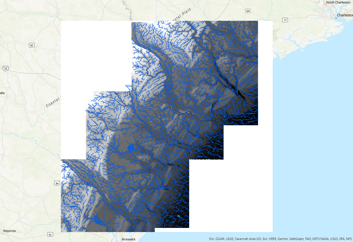
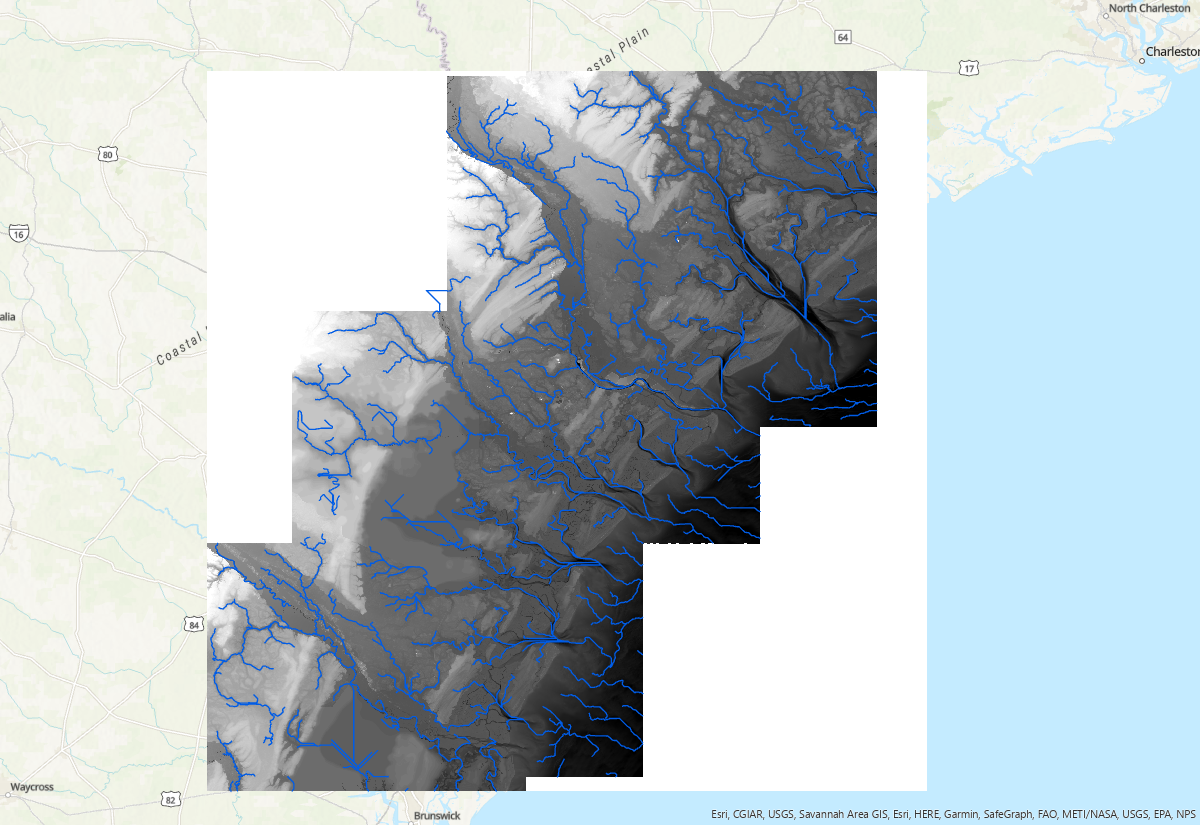
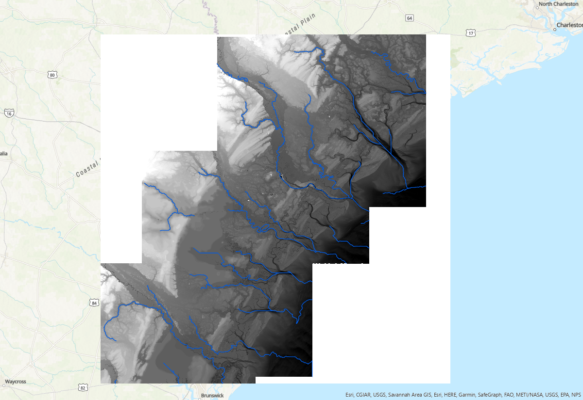
Flow accumulation threshold is a parameter that identifies grids with flow accumulation greater than the threshold as a stream network. It varies with DEM resolution, raster size and geomorphic complexity. The optimal threshold is a trial and error based on user's goal. The smaller threhold will generate denser network. Below are river network extracted with three different threshold: 1e5, 1e6, and 1e7, respectively:
Scripts
pyDEM can be downloaded from the RiverMeshTools repository.
Dependencies
numpy
GDAL
geopandas
shapely
richdem
Workflow
-
Pre-processing DEM (optional)
1.1 Split large files
Sometimes, it is necessary to split large tif files into smaller ones to avoid memory issues. Script split2tiles.py serves for this purpose:
Run the script with this command: Create tileindex shapefile, which will be used in the next step: 1.2 Merge tilesimport os, sys from osgeo import gdal dset = gdal.Open(sys.argv[1]) width = dset.RasterXSize height = dset.RasterYSize tilesize = 8100 for i in range(0, width, tilesize): for j in range(0, height, tilesize): w = min(i+tilesize, width) - i h = min(j+tilesize, height) - j gdaltranString = "gdal_translate -ot Float32 -of GTIFF -srcwin "+str(i)+", "+str(j)+", "+str(w)+", " \ +str(h)+" " + sys.argv[1] + " " + sys.argv[2] + "_"+str(i)+"_"+str(j)+".tif" os.system(gdaltranString)
This process is needed when Each tile and its 8-connected rasters are mereged into one raster file, which will be used in the next step.import subprocess import multiprocessing as mp import numpy as np import geopandas as gpd from osgeo import gdal def merge_tiles(itile, df, maps, locations): dx = [-8100, 0, 8100, -8100, 0, 8100, -8100, 0, 8100] dy = [-8100, -8100, -8100, 0, 0, 0, 8100, 8100, 8100] ullon, ullat = int(df.location.split('_')[2]), int(df.location.split('_')[3].split('.')[0]) tiles = [] for j in np.arange(9): try: ilon = ullon + dx[j] ilat = ullat + dy[j] key2 = f'{ilon}_{ilat}' tile_idx = tilemaps[key2] tiles.append(locations[tile_idx]) except: print(f'No tile') cmd = f'gdal_merge.py -n -9999 -o Merged/JAPAN_merged_{str(itile).zfill(3)}.tif' subprocess.call(cmd.split()+tiles) if __name__ == '__main__': gdf = gpd.read_file('tileindex_japan_dem.shp') tilemaps = dict() for i, p in enumerate(gdf['location']): x = gdf.iloc[i].location.split('_')[2] y = gdf.iloc[i].location.split('_')[3].split('.')[0] key = f'{x}_{y}' tilemaps[key] = i npool = 15 pool = mp.Pool(npool) pool.starmap(merge_tiles, [(i, gdf.iloc[i], tilemaps, gdf['location']) for i in np.arange(len(gdf))]) pool.close() del pool -
Extract channel networks
Extracting channel networks consists of three steps:
-
Fill or breach depressions
Algorithm "Priority-Flood + \(\epsilon\)" (Barnes et al., 2014) is used to fill depressions.
-
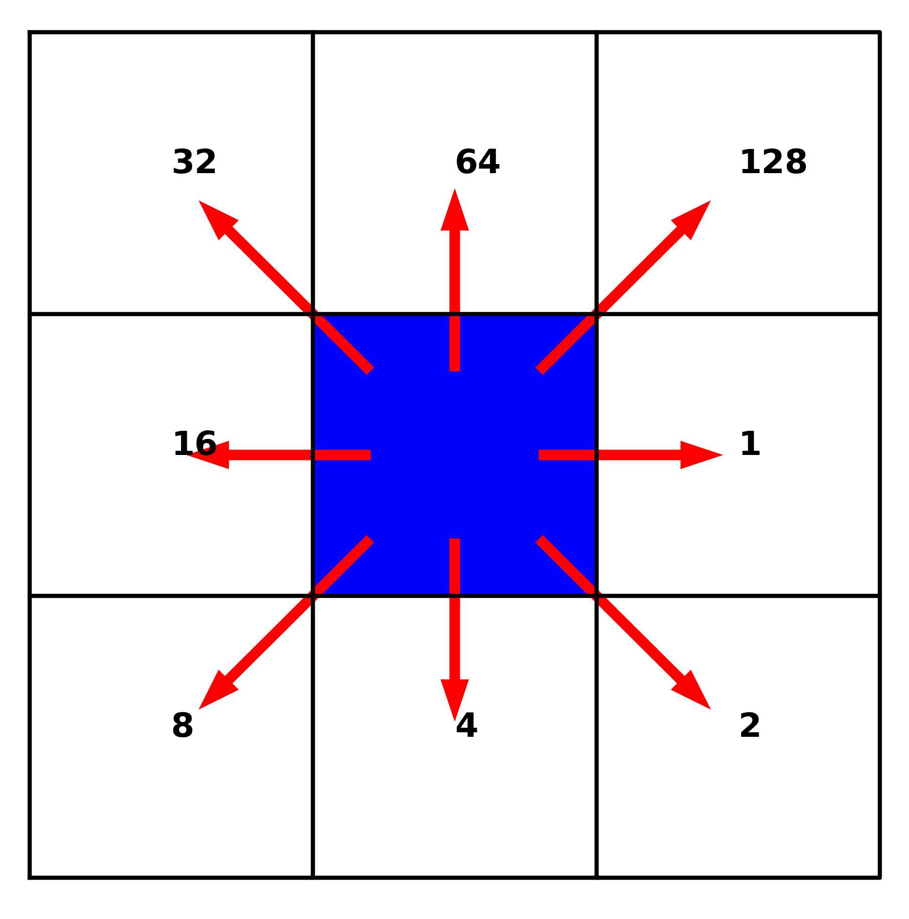
Calculate flow directions based on the given flow coordinate system. In pyDEM, flow directions use a D8 flow coordinate system that appears as follow:
-
Calculate flow accumulation
Flow accumulation is the total number of cells passing through each (raster) cell. With flow accumulations, we can apply a presccribed threshold to determine which cells should be included in the final digital stream network.
The details of the algorithm can be found in Ye et al. (2023).
Sample applications
Two example applications can be found under subdirectories from pyDEM_Samples.tar.
The subdirectory "Serial" contains a Python script run_serial.py and an input file tiff/Savannah_river.tif. This can be used for a small domain.
The script reads:
import glob
import time
from pylib import *
from pyDEM.dem import *
import numpy as np

np.seterr(all='raise')

if __name__ == '__main__':
    #input tiff files
    files = glob.glob('tiff/Savannah_river.tif')
    files.sort()

    acc_limit = 1e7
    t0 = time.time()

    for fname in files:
        names = [fname]

        #output filename
        sname = f"./{fname.split('.')[0].split('/')[-1]}_{acc_limit}"
        print(sname)

        #declare a dem object
        S=dem()

        #read data
        if not os.path.exists('{}.npz'.format(sname)):
            S.proc_demfile(names,sname=sname,depth_limit=[-100,1000],subdomain_size=2e10)
        S.read_data('{}.npz'.format(sname))

        #compuate watershed information
        S.compute_watershed()

        #extract river network (area_limit: catchment area)
        S.compute_river(acc_limit=acc_limit)

        #write shapefile for river network
        gdf = S.write_shapefile(npt_smooth=None)
        gdf.to_file(f'{sname}.shp')
        print(f'It took {(time.time() - t0)/60} mins!')
run_mpi_vortex.py,
which can run with multiple nodes/cpus with mpi4py.
References
C. Barnes, R., Lehman, C., Mulla (2014). Priority-flood: An optimal depression-filling and watershed-labeling algorithm for digital elevation models. Computers & Geosciences 62, 117–127. doi:10.1016/j.cageo.2013.04.024.
Barnes, Richard. 2016. RichDEM: Terrain Analysis Software. http://github.com/r-barnes/richdem.
Ye, F., Cui, L., Zhang, Y., Wang, Z., Moghimi, S., Myers, E., Seroka, G., Zundel, A., Mani, S., Kelley, J.G.W. A parallel Python-based tool for meshing watershed rivers at continental scale, Environmental Modelling & Software, 166. https://doi.org/10.1016/j.envsoft.2023.105731.