Generate river map
Scripts
RiverMapper is available from the RiverMeshTools repository under schism-dev.
Usage
RiverMapper requires two inputs:
-
*.tif, which are DEM tiles in lon/lat from one or more sources.
-
a shapefile with a 'LineString' type, which contains a 1D river network.
Note
The 1D river network can be any reasonable approximation of the thalwegs. It can be:
- extracted from DEM using the method presented in the previous section
- or duplicated from the river network of a hydrological model such as the National Water Model
- or manually drawn for quick local touch-ups
The outputs include:
-
"total_river_arcs.map", which contains river arcs to be used for the final meshing in SMS.
-
other *.map files for diagnostic purposes.
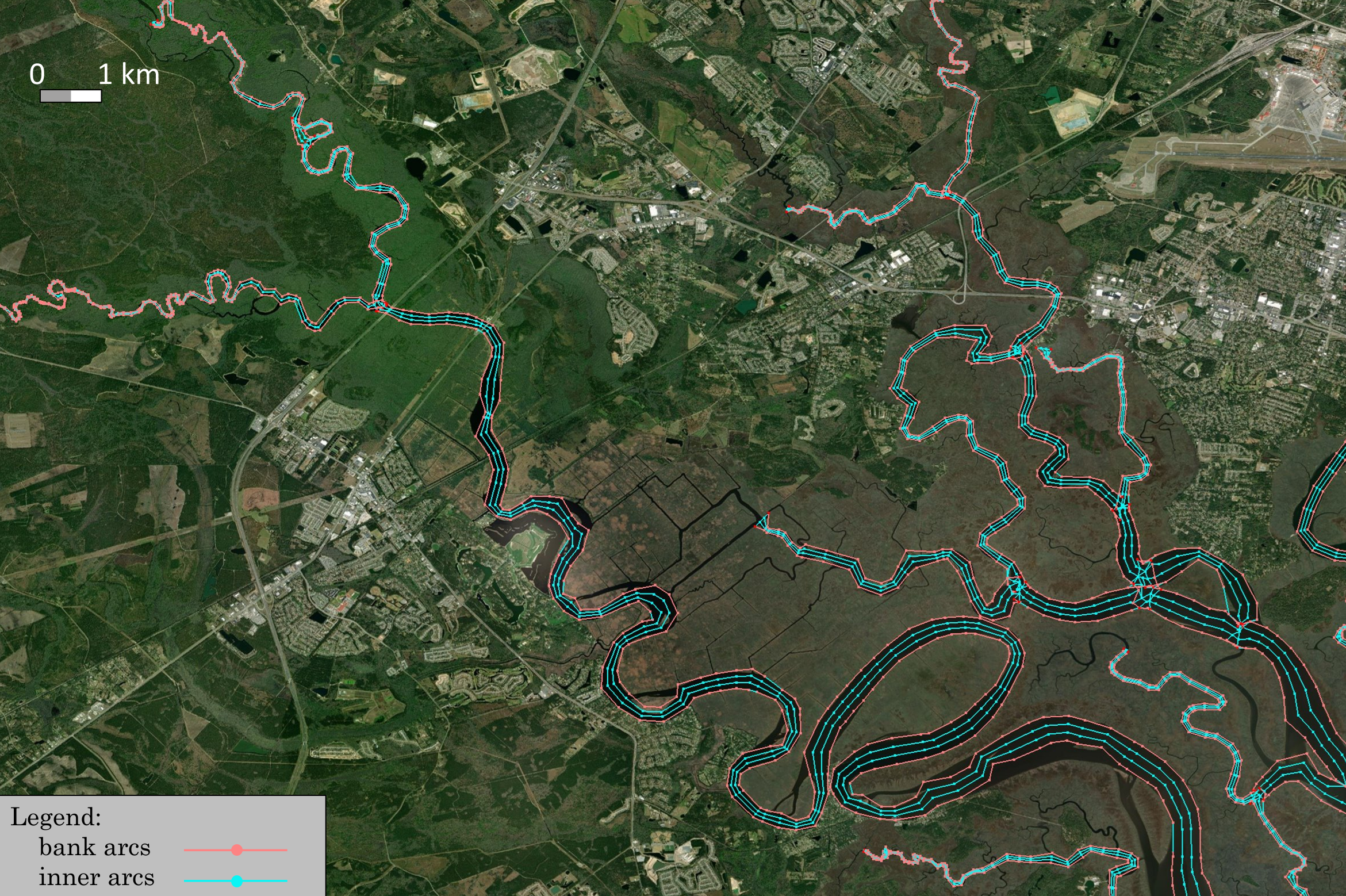
A sample output looks like this:
Sample applications
To test the RiverMapper tool, you can begin by extracting the "RiverMapper_Samples/" directory from RiverMapper_Samples.tar. It contains two subdirectories: "Serial" and "Parallel", providing sample applications for a smaller domain and a larger domain respectively. Each subdirectory contains a sample Python script and the necessary input files.
Meshing rivers in a small domain (Serial mode)
For a small domain (covering one or two states), a direct function call to the serial "make_river_map" suffices. See the sample script:
, which reads:from RiverMapper.make_river_map import make_river_map
if __name__ == "__main__":
'''
A sample serial application of RiverMapper
'''
make_river_map(
tif_fnames = ['./Inputs/DEMs/GA_dem_merged_ll.tif'],
thalweg_shp_fname = './Inputs/Shapefiles/GA_local.shp',
output_dir = './Outputs/',
)
Under the directory "RiverMapper_Samples/Serial/", execute the serial script like this:
Note
- Although only one DEM tile is used in this example, but multiple DEM tiles are allowed.
- If the tiles are from different DEM sources, they should be arranged from high to low priority in the list. Tiles from the high priority DEM source should have high fidelity and high resolution.
- The script allows DEM tiles of different sizes and shapes.
Meshing rivers in a large domain (Parallel mode)
For a large domain such as STOFS3D Atlantic, a parallel driver is provided to automatically group thalwegs based on their parent tiles, then distribute the groups to parallel processors.
The sample parallel script is:
, which reads:from mpi4py import MPI
import os
from RiverMapper.river_map_mpi_driver import river_map_mpi_driver
if __name__ == "__main__":
comm=MPI.COMM_WORLD
# ------------------------- sample input ---------------------------
dems_json_file = './Inputs/DEMs/dems.json' # specifying files for all DEM tiles
thalweg_shp_fname='./Inputs/Shapefiles/LA_local.shp'
output_dir = './Outputs/' + f'{os.path.basename(thalweg_shp_fname).split(".")[0]}_{comm.Get_size()}-core/'
# ------------------------- end input section ---------------------------
river_map_mpi_driver(
dems_json_file=dems_json_file,
thalweg_shp_fname=thalweg_shp_fname,
output_dir=output_dir,
comm=comm
)
In stead of specifying a file list for the DEM tiles as in the serial example, the first argument takes a *.json file that specifies multiple sets of DEMs, for example:
{
    "CuDEM": {
        "name": "CuDEM",
        "glob_pattern": "./Inputs/DEMs/CuDEM/*.tif",
        "file_list": [],
        "boxes": []
    },
    "CRM": {
        "name": "CRM",
        "glob_pattern": "./Inputs/DEMs/CRM/*.tif",
        "file_list": [],
        "boxes": []
    }
}
Note
-
For each DEM source, specify a glob pattern and/or a list of file names; if both are specified, the script will pool all files together and take the unique files.
-
No need to manually specify the bounding "boxes", just leave them empty.
-
Different DEM products should be arranged from high priority to low priority. The order of the dictionary key ("CuDEM" and "CRM") is preserved as long as you are using Python 3.7 or a later version. We may replace the regular dictionary to OrderedDict if there is a need.
Under the directory "RiverMapper_Samples/Parallel/", execute the parallel script like this:
The exact mpi command may vary based on your system.
Advanced Parameterization
Mandatory input parameters
In the "Serial" and "Parallel" examples above, you may have noticed there are 3 mandatory Inputs:
| parameter | explanation |
|---|---|
| tif_fnames (or a *.json file if there are many tiles) | a list of TIF file names. These TIFs should cover the area of interest and be arranged by priority (higher priority ones in front) |
| thalweg_shp_fname | name of a polyline shapefile containing the thalwegs |
| output_dir | must specify one. |
Optional input parameters
In addition to the mandatory inpouts, RiverMapper provides a few parameters to fine tune the output polylines or generate special features like levees or pseudo-channels.
| parameter | type | explanation |
|---|---|---|
| selected_thalweg | numpy array | Indices of a subset of thalwegs for which the river arcs will be sought; mainly used by the parallel driver |
| output_prefix | string | a prefix of the output files, mainly used by the caller of this script; can be empty |
| mpi_print_prefix | string | a prefix string to identify the calling mpi processe in the output messages; can be empty |
| MapUnit2METER = 1 | float | no need to change; to be replaced by projection code, e.g., epsg: 4326, esri: 120008, etc. |
| river_threshold | float | minimum and maximum river widths (in meters) to be resolved |
| elev_scale | float | scaling factor for elevations; a number of -1 (invert elevations) is useful for finding ridges (e.g., of a barrier island) |
| outer_arc_positions | a list/tuple of floats | relative position of outer arcs, e.g., (0.1, 0.2) will add 2 outer arcs on each side of the river (4 in total), 0.1 * riverwidth and 0.2 * riverwidth from the banks. |
| length_width_ratio | float | a ratio of element length in the along-channel direction to river width; when a river is narrower than the lower limit, the bank will be nudged (see next parameter) to widen the river |
| i_close_poly | bool | whether to add cross-channel arcs to enclose river arcs into a polygon |
| i_blast_intersection | bool | whether to replace intersecting arcs (often noisy) at river intersections with scatter points (cleaner) |
| blast_radius_scale | float | coefficient controlling the blast radius at intersections, a larger number leads to more intersection features being deleted |
| bomb_radius_coef | float | coefficient controlling the spacing among intersection joints, a larger number leads to sparser intersection joints |
| snap_point_reso_ratio | float | scaling the threshold of the point snapping; a negtive number means absolute distance value |
| snap_arc_reso_ratio | float | scaling the threshold of the arc snapping; a negtive number means absolute distance value |
| i_DEM_cache | bool | Whether or not to read DEM info from cache. Reading from original *.tif files can be slow, so the default option is True |
| i_OCSMesh | bool | Whether or not to generate outputs to be used as inputs to OCSMesh. |
| i_DiagnosticsOutput | bool | whether to output diagnostic information |
| i_pseudo_channel | int | 0: default, no pseudo channel, nrow_pseudo_channel and pseudo_channel_width are ignored; 1: fixed-width channel with nrow elements in the cross-channel direction, it can also be used to generate a fixed-width levee for a given levee centerline =2: implement a pseudo channel when the river is poorly defined in DEM |
| pseudo_channel_width | float | width of the pseudo channel (in meters) |
| nrow_pseudo_channel | int | number of rows of elements in the cross-channel direction in the pseudo channel |
You can change the values of these parameters so that the output river map better fits your application (otherwise default values are used). For example, if you want to add two pairs of outer arcs that flank the main river channel, you can do:
    make_river_map(
        tif_fnames = ['./Inputs/DEMs/GA_dem_merged_ll.tif'],
        thalweg_shp_fname = './Inputs/Shapefiles/GA_local.shp',
        output_dir = './Outputs/',
        outer_arc_positions = (0.1, 0.2),
    )
Parameter presets
Tuning the parameters may not be easy at first because there are many of them. To simplify the parameter configuration, RiverMapper offers a class called "ConfigRiverMap", which provides commonly used parameter presets. These presets are "class methods" in config_river_map.py, and each preset (class method, or factory method) comes with a short description in the code.
For example, the preset "LooselyFollowRivers" means that "Small-scale river curvatures may not be exactly followed, but channel connectivity is still preserved", and this is the sample code:
    from RiverMapper.config_river_map import ConfigRiverMap

    river_map_config = ConfigRiverMap.LooselyFollowRivers()
    make_river_map(
        tif_fnames = ['./Inputs/DEMs/GA_dem_merged_ll.tif'],
        thalweg_shp_fname = './Inputs/Shapefiles/GA_local.shp',
        output_dir = './Outputs/',
        **river_map_config.optional,
    )
Another utility of the "ConfigRiverMap" class is to facilitate the parameter transfer from the parallel driver to the core routine. The stardard way of setting the parameters in the parallel mode is as follows:
from mpi4py import MPI
import os
from RiverMapper.river_map_mpi_driver import river_map_mpi_driver
from RiverMapper.config_river_map import ConfigRiverMap

if __name__ == "__main__":
    comm=MPI.COMM_WORLD
# ------------------------- sample input ---------------------------
    dems_json_file = '/sciclone/schism10/Hgrid_projects/STOFS3D-V6/v16/Inputs/dems.json'  # specifying files for all DEM tiles
    thalweg_shp_fname='/sciclone/schism10/Hgrid_projects/STOFS3D-V6/v16/Shapefiles/CUDEM_Merged_for_v16.shp'
    output_dir = './Outputs/' +  f'{os.path.basename(thalweg_shp_fname).split(".")[0]}_{comm.Get_size()}-core/'
    river_map_config = ConfigRiverMap()
# ------------------------- end input section ---------------------------
    river_map_mpi_driver(
        dems_json_file=dems_json_file,
        thalweg_shp_fname=thalweg_shp_fname,
        output_dir=output_dir,
        river_map_config=river_map_config,
        comm=comm
    )
Comparing with the parallel example in the previous section, the above example adds a few lines of code that does the following:
- importing the "ConfigRiverMap" class
- creating a default configuration "river_map_config",
- passing the configration to the parallel driver.
Since the default configuration is used, this example is essentially the same as the previous parallel example. But it facilitates further parameter tweaking, e.g.:
    river_map_config = ConfigRiverMap.LooselyFollowRivers()
    river_map_config.optional['outer_arc_positions'] = (0.1, 0.2)
    river_map_config.optional['i_real_clean'] = True
More parameter presets
By tweaking the parameters, RiverMapper can also aid in the meshing of other channel-like features.
Levees
In the STOFS-3D-Atlantic domain, levees are important features to be incorporated in the model mesh. Instead of parameterizing them as hydraulic structures, the levees are explicitly represented by meter-scale elements, with two rows of nodes resolving the feet of the levee and another two rows resolving the top of the levee:
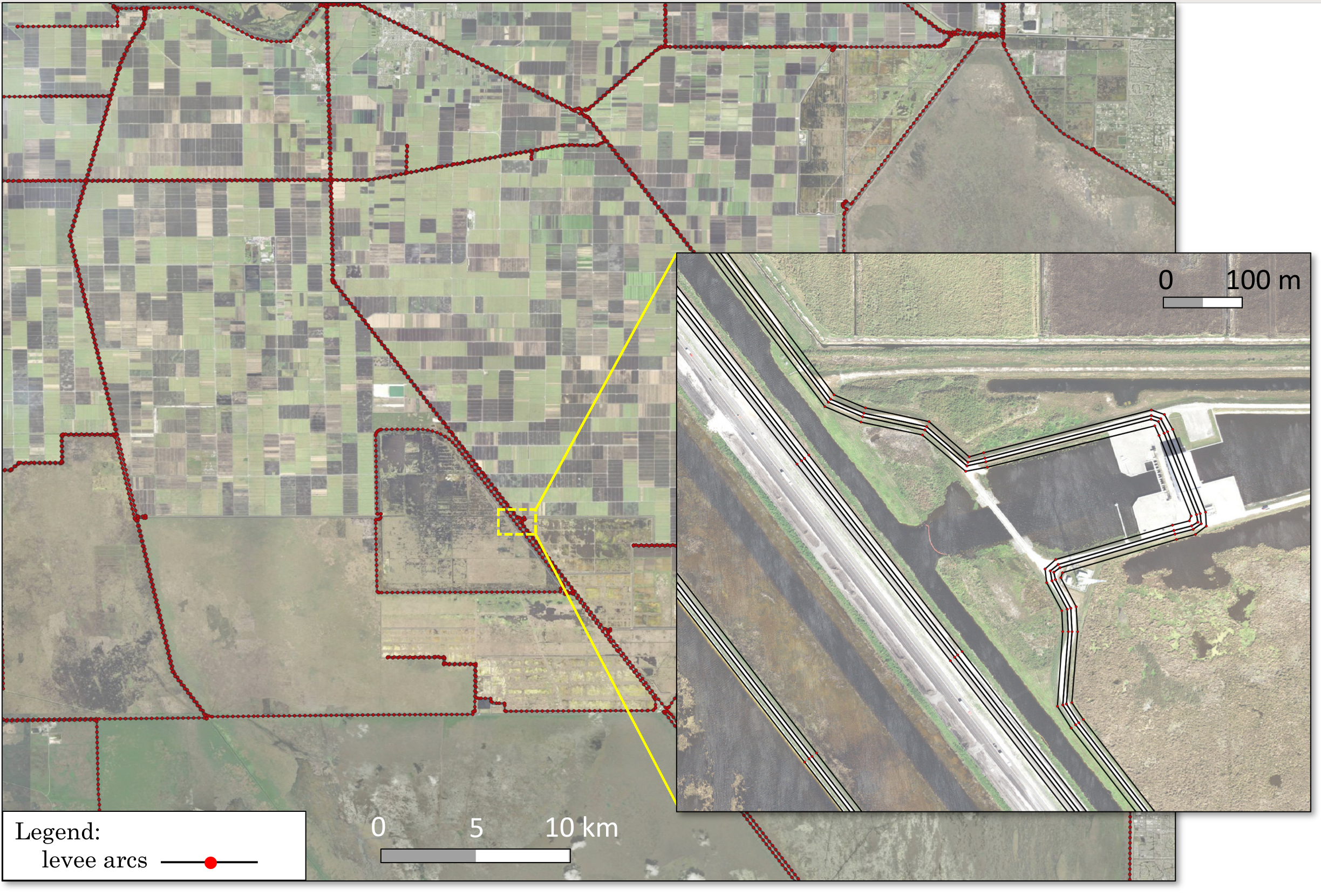
With the levee centerlines available from National Levee Database, the levee map can be easily made by invoking the pseudo channel option of RiverMapper:
Notice that the along-channel (in this case along-levee) resolution also adapts for bends, just like for rivers.
Barrier islands
Barrier islands are long and narrow topographical features similar to river channels. In fact, the map of a barrier island can be made in the same way as river channels if the sign of the DEM's elevation values is inverted.
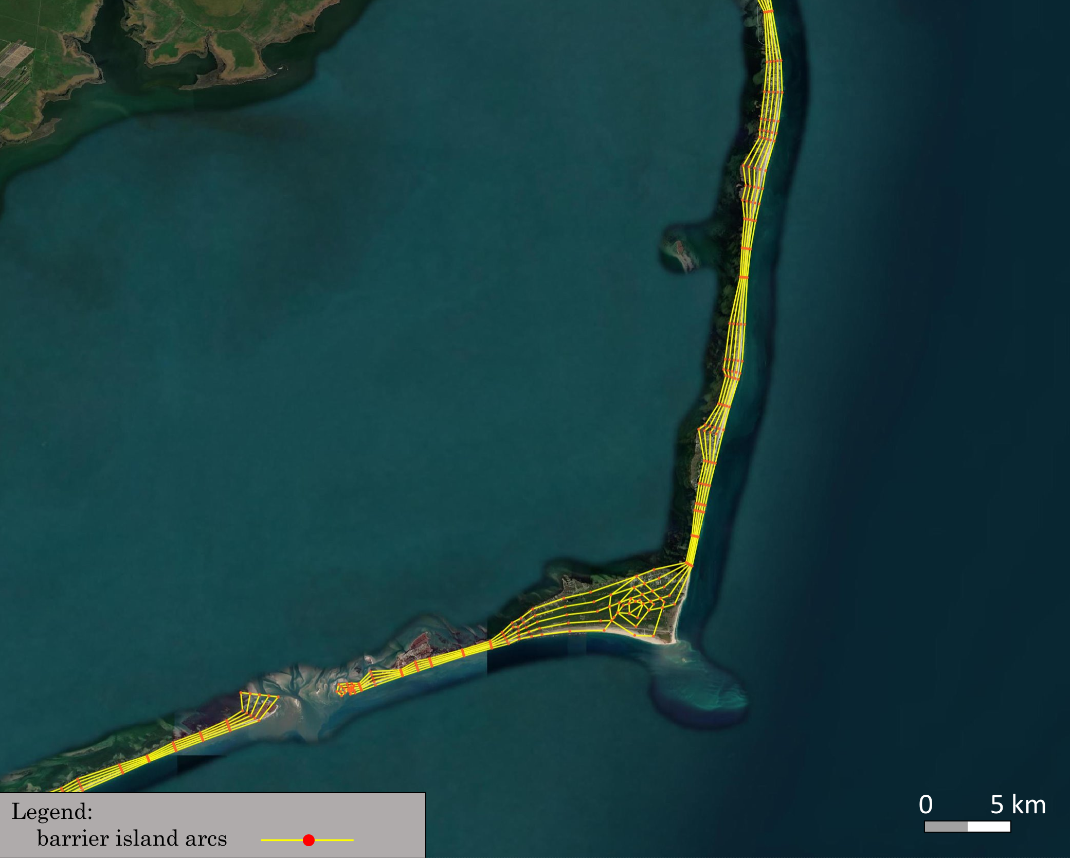
This can be done by setting the optional parameter "elev_scale" to "-1", or directly invoking the preset "BarrierIsland":
Note
The above two sample applications can also be found in RiverMapper_Samples.tar
Experimental Features
Global arc cleaning
There is an optional input in for "make_river_map" called "i_real_clean", which defaults to False. When turned on, an extra cleaning process will be applied to all arcs. However, this process is not efficient enough for large applications at the time being, specifically it increases the total run time by 7 to 8 times. Another issue is that it does not guarantee all river arcs are closed to form polygons, which affects OCSMesh. Updates in the near future will address the efficiency issue first.